Those of us in Oklahoma this morning had quite a nice surprise when at about 9:06 AM local time the ground shook and many experienced an earthquake centered just outside of Norman, OK. I live on the bottom floor of a 2-story apartment building and was standing when the quake hit. I head a loud noise like a vehicle roll over, then felt the shake. My blinds shook and a few plates rattled together. After immediately realizing what it was I estimated the duration as about 15 seconds, but some of that could have been remnant swinging of objects in my house.
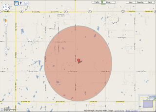
The initial rating was 4.5 from the USGS (United States Geological Survey), and 5.1 from the OGS (Oklahoma Geological Survey). These estimates have been revised many times over the day, as well as the location and depth of the quake. The estimates seem to be settling around a 4.3-4.5 magnitude with a center just west of lake Thunderbird in Norman, OK. Below is a google map (image: J. Leeman) plotting the OGS estimate of the center with the error as the shaded region. This uncertainty is about 1.24mi in N/S and 1.12mi in E/W. The USGS estimate is currently much less constrained, but subject to revision.
The earthquake was widely felt with reports from surrounding states. If you felt the quake you should fill out the 'Did you Feel it?' question form available on the USGS website. Many thousand reports have been submitted so far and data gathered from over 40 stations. The next image is courtesy of Bill Wilburn, planetarium director at the Science Museum of Oklahoma. Following that is the plot of arrival times at different stations from Steve Piltz, Tulsa NWS.
We are also fortunate to currently have the earthscope array stationed in Oklahoma. The next figure shows current seismic stations on the OGS page. The yellow stations are earthscope. Those stations appear to have been saturated, but it could be a plotting issue. I will not know until I can get ahold of the data.
The final two images are the Carlsbad, NM East Tower seismogram and a focal mechanism plot. The Carlsbad plot just shows that the earthquake was still very detectable in NM and makes it easy to see why it was recorded by so many stations! The focal mechanism plot (or moment tensor solution) plots the first movement (up/down) of the ground at the stations to determine the type of earthquake/fault. Here we see evidence for a strike-slip fault along a SW-NE or SE-NW line. Simply put this means the ground sheared on a horizontal plane, not shearing along a slanted/vertical face as in normal or transverse faults.
I'll post more in a future post if we learn anything else significant from/about this quake. Maybe also some neat arrival plots and a discussion of wave types. As a note the largest earthquake recorded that originated in Oklahoma was in the El Reno area on April 9, 1952 with a magnitude of 5.5. The USGS has the following to describe that quake:
This earthquake caused moderate damage at El Reno, Oklahoma City, and Ponca City, including toppled chimneys and smokestacks, cracked and loosened bricks on buildings, and broken windows and dishes. One crack in the State Capitol at Oklahoma City was 15 meters long. Slight damage was reported from many other towns in Oklahoma and from some towns in Kansas and Texas. The earthquake was caused by slippage along the Nemaha fault. Felt over most of Oklahoma and in Arkansas, Iowa, Kansas, Missouri, Nebraska, and Texas.


